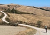
Transardinia MTB: seven-stage GPS route across Sardinia
Route information
- Region / area
- Sardegna
- Province / area
- Sassari
- Country
- Italy
- GPX starting point
- Lat. 40.92172, lon. 9.50408
- Track length
- Approximately 449.3 km
Distance and elevation are estimates from the GPX and may differ from GPS-device calculations. The file contains multiple segments: gaps between separate segments are not included in the calculation.
This GPX brings together the seven MTB stages of the Transardinia, from Olbia to Cagliari through Sardinia’s interior, including Oliena and Orgosolo.
The route is long and varied. There is no guarantee that every section is currently passable, and the original notes recommend support from an experienced operator. This MTB track must not be confused with a different gravel or bikepacking version using the same island-crossing name.
Find the individual stage tracks in the route table; untranslated entries are identified there.
Transardinia at a glance
The historical presentation describes a north–south traverse through some of Sardinia’s highest and wildest mountains. It gives approximately 450 km and 10,000 m of ascent in its introduction, while its detailed summary lists 419.6 km, also rounded there to 450 km. Those differing source figures have not been silently reconciled; consult the available GPX estimate for this file.
| Historical route summary | Figure given in the original |
|---|---|
| Natural surfaces | 78% |
| Tarmac | 22% |
| Gravel roads and mule tracks | 302.4 km |
| Trails | 30 km |
| Tarmac distance | 94.6 km |
| Average daily distance | 61 km |
| Average daily time | 8–9 hours |
| Average daily ascent / descent | 1,428 m / 1,428 m |
| Stated overall difficulty | Medium to high |
| Municipal areas crossed | 26 |
These are historical itinerary figures and planning descriptions, not a field verification of the present route.
Historical departure dates
The old programme listed 24 April–1 May, 29 May–5 June and 2–9 October, without specifying a year in this page. It described groups of 10–15 maximum, with a minimum of eight, and possible custom dates for established groups.
These are archive details, not available departures or current booking terms.
TranSardinia Classic: the original stage programme
Day one: arrive in Olbia
The programme began with individual arrival at a hotel near Olbia, a late-afternoon or evening meeting with IchnusaBike guides, bicycle checks, dinner and an overnight stay.
Day two: stage one, Olbia to Mamone
Pilgrims’ paths and old transhumance routes lead away from the Costa Smeralda towards the wide Alà dei Sardi plateau. Silence and open landscapes set the character for the crossing. The original programme ended at a small agriturismo/refuge, with Sardinian food.
72 km · 1,800 m ascent, as listed in the original itinerary.
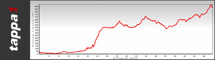
Day three: stage two, Mamone to Oliena
A transition stage before the harder days, crossing oak woodland towards the Nuragic sacred well of Su Tempiesu. Repeated climbs and descents continue to Oliena, then the hotel at the foot of the Supramonte.
62 km · 1,400 m ascent.
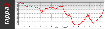
Day four: stage three, Oliena to Fonni
The source describes this as the hardest day for surface conditions, but also particularly rewarding. The long climb towards the Supramonte offers steep valley views before continuing towards the evening accommodation, dinner and conversation by the fireplace.
51 km · 1,500 m ascent.
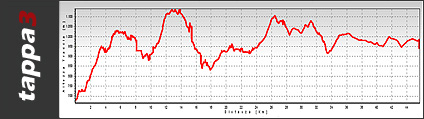
Day five: stage four, Fonni to Desulo
A climb towards Bruncu Spina, where mountain weather can be severe. The historical description celebrates far-reaching views, from the direction of Corsica to the Gulf of Cagliari, in suitable visibility.
A technical descent leads towards the refuge, where the programme described another dinner based on local produce.
Approximately 53 km · 1,700 m ascent.
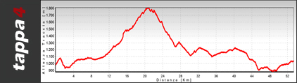
Day six: stage five, Desulo to Seui
On the Ogliastra side of Gennargentu, a more open, dry landscape replaces the oak and chestnut woods of earlier stages. The route visits the ruins of the Nuragic village of Orruinas, follows a charcoal-burners’ path and climbs again towards views of Perda Liana.
The day ends in Seui, an Ogliastra town with a strong sense of its past.
65 km · 1,700 m ascent.
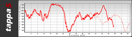
Day seven: stage six, Seui to Villasalto
Another day of climbing begins on an old mule track once used by village women going to the river to wash clothes. The route crosses the sparse Salto di Quirra plateau before descending below Villasalto. The old programme promised Sardinian cooking at the end of the day.
72 km · 1,850 m ascent.
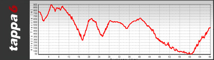
Day eight: stage seven, Villasalto to Cagliari
The programme included time in the village and a visit to a small traditional mirto producer. Beyond Monte Genis, the landscape opens towards the Gulf of Cagliari and the sea.
The original schedule ended with a beach stop, lunch, farewells and transfers to the port or airport. An optional extra stay in Cagliari was mentioned. These are descriptions of the former package, not current service commitments.
52 km · 1,405 m ascent.
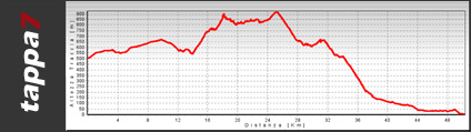
All original stage distances and ascent figures are approximate.
Nearby routes
Other routes whose starting points are near this route. This does not imply similar difficulty or terrain.